Mapping and operator support for forestry machines
A mapping tool and operator support for forestry machines—built to provide better decision support in the field. Especially valuable when you need to find the right trees, avoid sensitive areas, or follow a plan with high precision.
Map support in the cab
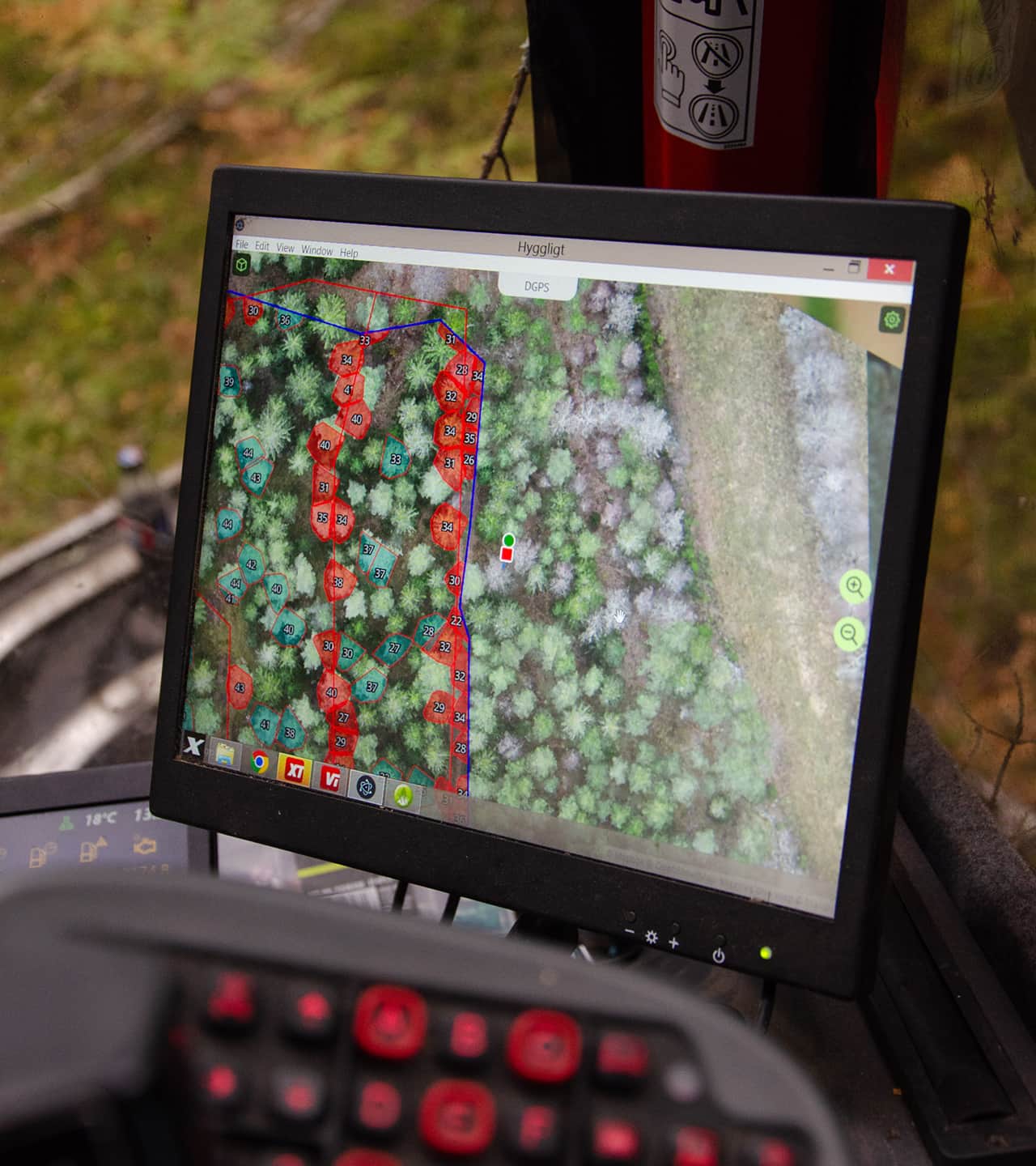
View your position, map layers, and visualizations while you work.
Precise positioning
Get better support when specific trees must be found—or avoided.
Plan before harvesting
Visualize stand instructions (traktdirektiv) from our planning tool.
The right information—at the right place, at the right tree
The operator has real-time access to maps, position, and visualizations. That makes it easier to follow the plan and work with high precision when the right trees and areas need to be selected—or avoided.
- Boundaries, soil moisture, terrain, trees, and your own layers
- Better support for selection cutting (plockhuggning), thinning, and precision work
- A standalone system, separate from the machine’s standard computer

App-only or a complete solution
Our solution comes in two levels. Use the mapping tool on your existing computer or tablet—or choose a setup with a dedicated screen and hardware for higher precision.
Mapping tool
A mapping tool that shows your position, map layers, and visualizations in the field. Use your own screen—or one from us.
Learn moreComplete operator support
Mapping tool, a dedicated in-cab screen, and precise positioning of the harvester head (aggregatet) using an external positioning puck.
Learn moreA mapping tool for work in the forest
See your current position together with relevant map layers, visualizations, planning data, and stand instructions (traktdirektiv). Filter the view so you only see what you need in the moment.
Position and movement
Current position, historical track, and the harvester head (aggregatet) position
Map layers and analysis
Property boundaries, soil moisture, terrain models, conservation considerations, timber volume, and basal area (grundyta)
Planning data
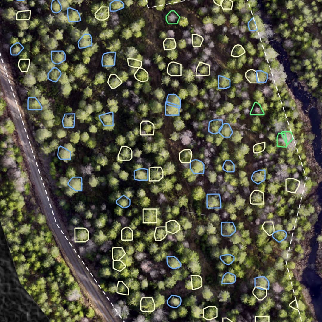
Specific trees, skid trails/forwarding trails (stickvägar), areas, comments, and your own raster and vector layers
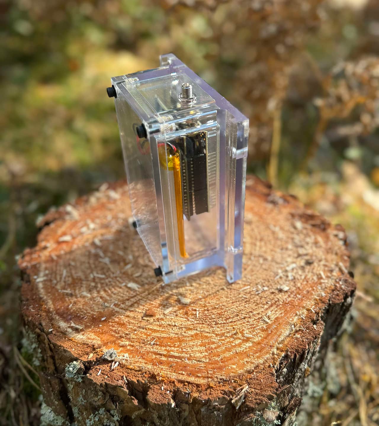
Precise positioning of the harvester head
When high precision is required, the solution can be complemented with a positioning puck on the harvester head (aggregatet) that shows its position on the map in real time. This provides significantly better accuracy than relying only on the machine’s GPS.
This is especially valuable when specific trees or areas need to be found—and when work is done in continuous-cover (hyggesfritt) or other selective harvests.
Connect planning and execution
The solution can be integrated with Hyggligt’s planning tool. That means what’s planned ahead of harvesting—including stand instructions (traktdirektiv) and other relevant data—can also be visualized out in the forest.
- Draw and plan before work begins
- Show stand instructions (traktdirektiv) and the same data out in the field
- Adjust what’s shown on the map depending on the assignment
- Improve alignment between manager, contractor, and operator
For contractors, managers, and partners
Hyggligt’s operator support can be used by multiple stakeholders in the same value chain. It’s broadly useful across forestry, but especially strong in work where precision and clear guidance are critical.
Contractors
Get clearer in-cab support with a map tailored to the assignment. Better decision support and an easier time following the plan in practice.
Forest managers
Create better conditions for plans and stand instructions (traktdirektiv) to be followed in the field. Simplify planning with automated map layers and visualizations.
Machine manufacturers and partners
Interested in offering similar functionality in—or alongside—your machines? Reach out about collaboration or integration.
Choose what fits your way of working
Start simple—or choose a more complete solution depending on how much support and precision you need. We’re happy to recommend the right setup based on your fleet, use case, and requirements.
Mapping tool
Detta ingår
- Mapping tool / app
- GPS positioning
- Map layers and visualizations
- Option for custom data layers
- Onboarding support
Complete operator support
Detta ingår
- Mapping tool / app
- GPS positioning
- Map layers and visualizations
- Option for custom data layers
- Onboarding support
- Precise and reliable harvester head (aggregatet) positioning
- Standalone screen/tablet for the cab
- Mount-ready hardware
Contact us to book a demo
We’ll show you how the solution works in practice and propose a setup based on your fleet, usage, and needs.

- Email: hej@hyggligt.se
- Phone: +46 73-850 46 75